Kml File
Advertisement
Earth Addresser v.1.0
Earth Addresser takes the addresses from your Address Book and writes them to a 'KML' file which Google Earth can open to display your friends' places right on the map.
Advertisement
UTrekGE v.1.2
Generate an up-down graph for a path in KML file of Google Earth.

TRIANGULATION for AutoCAD v.2.1
An add-on for AUTOCAD, for the TRIANGULATION of a set of point, isolines, KML creator, the VOLUME of a set of 3dface entities, loading of XYZ points files and sections.

Topography in AutoCAD v.2.3
An add-on for AUTOCAD or BricsCAD, for the TRIANGULATION of a set of point, isolines, KML 2D and 3D creator, the VOLUME of a set of 3dface entities, loading of XYZ points files, surface flatness and sections.
MapAWay v.1.8.0.195
Features - Supporting new way to make PathAway maps having 2048*2048 resolution. - Generaing directly map file for Palm PDA with PathAway DLL. Key Features - You don't need to prepare map files any more.
EasyAcreage v.1.0
EasyAcreage is program for WinXP or Vista program that allows you to calculate area from KML files exported out of Google Earth. This means you do not even have to leave your house to measure a field anymore.
GE-Graph v.2.2.21
GE-Graph (GE-Graph: Graph for GoogleEarth) helps you to make graph into Google Earth to illustrate your presentations, and papers. GE-Graph was developed to generate graphs from kml files saved by GE.
GPicSync v.1 28
GPicSync automatically inserts location in your photos metadata so they can also be used with any 'geocode aware' application like Picasa/Google Earth, Flickr, loc.alize.us.
Korti v.2 8
Korti is a Google Earth plugin which allows you to see the unique 3D satellite map of Korti within your Google Earth application. Korti provides you a detailed satellite imagery and geographic information about this geographic place.
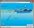
DRAGSENS v.4.01
DRAGSENS Geo Software is used for the exact position estimation of a towed body, sensor, camera, array or net, dragged behind a ship, aircraft or vehicle. The software allows a real-time estimation of the position of a dragged sensor.